Patagonia Journal
What’s new, Buenos Aires?
Somehow when planning this trip I completely missed the fact that it would be an entire trip of Évita song cues. This will no doubt make some of our hikes a Lloyd Webber jukebox, which should at least liven up the longer climbs. That or Stephen will return with some hiking pole related injuries.
Our flights to Miami and onward to BA were both delayed by several hours, an annoyance but not too bad since at least that meant we weren't running through an airport in a panic. A long boring day and night of travel finally brought us to BA, a huge city in the midst of a summer heat wave. We packed for cold and rainy weather, so the city kindly obliged, with the temperature dropping and the rain starting almost as soon as we arrived. We had just enough time to clean up and unpack, then went out for a short city tour.
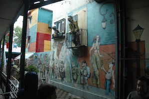
We visited La Boca, which used to be an immigrant community near the port, but is now an artist community. Argentina still has a very open immigration policy, and was built by immigrants from Italy, Spain, Germany, and the rest of Europe. The historian leading our tour pointed out the influence of central state education to create the definition of "Argentinian" that is essentially a created construct. There is little preservation of these individual cultures, although some survives in food, particularly a love of pizza and pasta.
BA has many different architectural styles, depending on the era the neighborhoods were settled. There is a period clearly inspired by Haussmann, with very Parisian apartments facing the street. There is a later period that is all Art Deco, and yet later a Peronist brutalist wave of concrete and utilitarianism. These areas are very distinct, although their fortunes have waxed and waned with time.
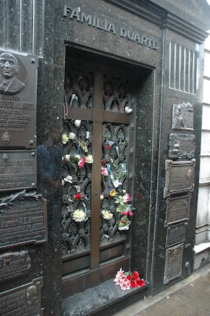
One popular tourism site is the Ricoleta cemetery. This secular cemetery is where most of the rich and famous of the last 150 years are interred. The gravesites are actually buildings, with several basement levels for internment and often a shrine at the ground level. Some people are cremated and interred in wooden boxes on shelves, others in coffins 1 or 2 layers below ground level. The buildings are constructed of marble or stone, often with glass doors with wrought iron screens. You can peek in between the bars to see the small altar and plants, although in some cases the family can't manage the upkeep and they become dirty, overgrown, or broken. The plots are owned and very expensive; one recently changed hands for a quarter of a million dollars. All the recent presidents are buried here, and Eva Peron's body was interred here after it appeared in the 60s. This is clearly a pilgrimage site, people walking forward slowly in a hush, leaving flowers and tokens.
Monday we are heading to Ushuaia, the southernmost city in the world. Unfortunately there is a local transit strike in Argentina, so our 10a flight from the domestic airport turned into a 4p flight from the international airport. We do seem to be attracting flight delays. Steve and I took advantage of the delay to wander around a bit on our own, seeing the block-wide Theatre Colon (next playing Porgy and Bess, a rather bizarre slice of home). Hopefully we'll get in today sometime, and will simply move our planned hike in the national park to Wednesday morning. That or we'll just do a tour of airports. :-/
Next stop, Tierra del Fuego! I'm sure!
On this night of a thousand stars
So how does a place quite literally at the ends of the earth near Antarctica get named land of fire? Someone being sarcastic? 17th century land sales tactic similar to "Greenland"? Wishful thinking from a functionary in Madrid? The story we are told, which sounds pretty good, is that when the early sailors were passing close to land attempting to find a channel through to the pacific, the native tribes lit bonfires as a warning to their tribesmen further along. Given how many ships came to grief in the cold and treacherous waters of the south Atlantic and the beagle channel, it's not clear if the subtext was "those idiots are back" or "potential salvage coming your way". Magellan and crew finally made their way around Cape Horn, but the ratio of success to failure makes all the early explorers seem more than a little crazy.
Eventually, of course, people started settling here, although not until the late 19th century. Most of Patagonia was settled in a profit-driven rush over 30 years, as investors competed to clear and graze millions of acres. Towns were settled for expediency of cattle transport, and later as bases from which to fight Chile. The competition and friction between the two nations continues in this part of the border, to the point that there are few border crossings and fewer paved roads. The border crosses north to south across Isla Grande as a line drawn on a map by someone who clearly never needed to get anywhere, and the reason for the weird curve of islands that are currently Chilean is mysterious. The English also tried to settle and explore here, witness the Beagle channel (named for the famous ship) and other very English named Islas. The Islas Malvinas a few hundred miles off the coast to the east are a particularly sore point. (Watch the Top Gear Patagonia special for more on that...)
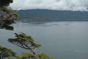
We hadn't really thought about it, but we are here in Ushuaia for the winter solstice, the longest day of the year. Our flight landed after 8pm, but it stayed light until almost 11, good since we got in so late. We ate dinner (quite good fresh pasta) while watching the sun set on the channel. Our hotel is right on the water, with a view of pretty much the whole town and the airport. Unfortunately we are so late that we can't do more than eat and go to sleep, but tomorrow we will head out on the channel in a Zodiac! Tonight we just wave to the cruise ships heading south to Antarctica.
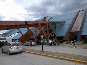
The airport is gorgeous, built of wood and stone, perched on a spit in the channel. It has a peaked roof with solar panels, and looks more like a ranch house than anything. Interestingly, it is the airport of "Ushuaia and the Islas Malvinas". More from the world's southernmost city tomorrow. For now I'll finish my Cape Horn IPA (the world's southernmost beer) and head to bed...
Birds fly out of here, so why oh why the hell can’t I?
Last night the sky finally got dark at almost midnight, and the sky started to get light again around 3:30am; technically there are about 5 hours of night, but the twilight and pre-dawn is so long that it is only a few hours of darkness. I'm writing this now at 10pm, and it's still light out and feels more like 4pm in a Boston winter!
In any event, we woke up this morning to find the breakfast room still closed, as apparently the nice lady who runs it had a flat tire. She arrived only about 20 minutes late and provided excellent cafe con lèche and scrambled eggs, so all was quickly forgiven (and apparently the tire is now ok). We set off this morning for the Estancia Harberton. This was the first estancia in the area, founded by an English missionary in the 1870s. He came to convert the local Yamana people; he didn't do terribly well at that, but did manage to raise hardy sheep. He wound up being granted 50,000 acres of land by the government, including dozens of islands in the Beagle channel. Now the 3rd, 4th and 5th generations of this family own the land, and they have converted to tourism.
Our group started on Gable island, one of the larger islands in the channel, a previous cattle island. We were taken out on a Zodiac about 20 minutes from the estancia to land on a rocky beach on this now deserted island. It was quite cold this morning, the high today was only about 52, and raining off and on all day. We were all bundled up in multiple layers and rain gear and even two hats apiece (a fleece cap for warmth, and a brimmed hat over that to shed rain). Fortunately as we hiked it warmed up and we slowly shed layers into our packs, the usual REI onion approach to the day. The trail was less a trail than an animal track, so we were often pushing through hardy shrubs (hardy = with thorns), so the slick rain gear was very welcome so we didn't get too attached to the island. Despite the conditions, the scenery was simply stunning. The channel is cold and damp, often with a stiff wind rushing through, and there can be a strong current. We were able to stand on top of the main hill of the island and look across to Port Williams in Chile (the southernmost TOWN in the world per Chilean tourism sources); there was surf on the shore. There was lovely bird life, including woodpeckers, ibis, lots of geese and ducks, and several cormorant species. Apparently some people saw a whale yesterday, but all we saw was a sea lion. It was a lovely hike and really gave you an idea of the challenges of living, farming, herding, really anything in this extremely remote and unforgiving land. This is one of the warmest days of the year! (I kept telling myself that when the cold rain got a little too cold.)
One of the newer problems in this part of Patagonia is beavers. A few mating pairs were introduced by the army in the 1970s when they were at war with Chile over the course of the channel and the boundary between the countries. The hope was that there would be a thriving beaver pelt industry that would drive settlement. That didn't really work out in any way, but the beavers have no natural predators and lots and lots of trees and water. They rapidly spread and there are thousands of them now, chewing their way through local lenga trees and creating inconvenient dams. We saw several areas of dead trees attributed to beaver dams leading to flooding. Several people in our group bemoaned the problem and asked if the beaver population could be controlled; Steve and I were more on the side of our mascot and their clearly excellent engineering skills.
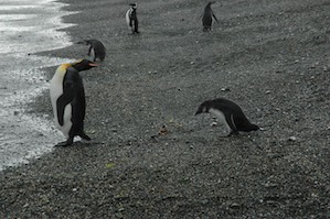
After a lovely stop and lunch in an old shepherd's hut (sounds way worse than it was; it's been repurposed), we moved on to the main attraction, so-called Penguin Island (previously Isla Martello). This small island in the middle of the channel was previously used for sheep, but in the 1970s a small colony of penguins moved in. There's no indication of why they chose this particular island out of all the available islands in the channel, although it is within sight of the Atlantic. In any event, a small group of Magellanic penguins decided to nest there year after year. In the 1990s a huge flood essentially ended cattle ranching in the area by killing a large portion of the herds. The penguins were unperturbed and came back that summer to nest. The family decided to build a penguin-focused business instead of trying to go back into cattle ranching, particularly as the area was becoming built up enough that free-range cattle and sheep on the main island had a tendency to wander into other people's herds and/or ovens. Now there are almost 4000 nesting pairs of Magellanic penguins, 35 or so pairs of Gentoo penguins, and 3 random King penguins who just showed up a few years ago and keep coming back. This is a small island with not much on it other than scrub. It's like a penguin kingdom.
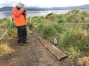
The estancia runs Zodiacs out into the channel to visit the penguins, a very limited number of people each day, and they self-regulate with naturalists and a walking path so that you can't disturb most of the nests. They asked us to stay at least 6 feet away from the penguins, but a) the penguins apparently have no sense of distance and b) they are everywhere, so that's actually quite hard to maintain. We spent an hour taking roughly 1000 photos of penguins. We were briefly regretting that we didn't bring a long telephoto lens, but let me assure you, it was unnecessary. When you have to zoom out to get the whole bird, you are probably ok on lens power. Naturally it started raining again, but it was so fascinating we just held a hat over the camera and kept going. :-) There was actually constant noise as they called to each other, this loud braying noise that reminds you why their cousins in Africa are called Jackass penguins. The nests were full, with cute little brown chicks being fed and warmed, and only occasionally stepped on (not by us!). We walked along the beach and saw one of the King penguins just standing there, staring at the water, looking very regal. The other, smaller penguins would sometimes come up behind him a bit to one side, looking either like subservient ministers or would-be assassins, depending on how sinister you like your penguin fanfic. As we walked up the boardwalk to the nesting area, at one point we were completely surrounded and had to excuse ourselves as we picked our way through, well under 6 feet away from about a dozen of the birds. Fabulous.
In any event, fully penguin-ed out, we rode the Zodiac back to the main island and wended our way over the gravel road to the highway to the hotel, about 90 minutes away. It's only about 40 minutes by water, but there aren't many roads out here! We had a lovely dinner watching the sun sink over the channel while the perpetual rain started again, and now it's almost 11pm and starting to get dark. Weird.
Tomorrow we visit the national park nearby, and then in the afternoon fly to Calafate and drive on to El Chaltén, in the Fitzroy national park. PENGUINS!
Another suitcase in another hall
Our second day in Ushuaia started well, with a nice hike through the national park near our hotel. This area along the Beagle channel is a lovely forested section, never used for agriculture and relatively unspoiled. At every little cove there are remnants of shell middens from the Yamana people, who once built huts on shore and fished in the unforgiving current. The forest is relatively short, with scrubby lenga trees and some beech, but nothing terribly tall. The underbrush is actually very reminiscent of the fynbos of the South African cape coast, which perhaps makes sense when you consider Pangea. As lovely as the hike was, though, there were zero penguins, which was vaguely disappointing. After our hike we took a quick shower and went to the airport for our flight to Calafate.
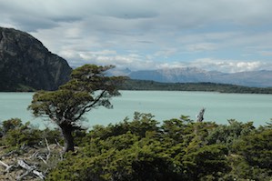
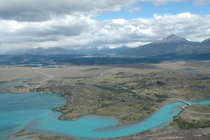
Calafate is the largest city in Argentinian Patagonia, and the central starting point for hiking this area. Unfortunately it's also about a 3 hour drive from El Chaltén, our destination for the night. We landed at around 4:30, then drove for hours across the plains. My impression of Patagonia is of cold, wet, windy landscapes. The plains we are driving are certainly cold and windy, but definitely not wet. It's semi-arid, almost desert, all brown and red-brown with scrub grasses and rocky hills in the distance, no trees to be seen. There are small lakes scattered throughout the countryside, varying shades of blue, at times startling against the red brown countryside. The colors are different due to the different minerals left by the glaciers...these lakes are all due to water runoff from the glaciers formed in the Andean ice field. This was once cattle country, but all we see for wildlife is a few guanacos (cousins to llama and alpaca, but without a hump). We drive Argentina's highway 40, which is both part of the Pan American highway and has a mythic status in this country similar to Route 66. It travels through this sparsely inhabited country, and you can go hours without seeing another car. After several hours we stop for dinner at an Estancia set above a river. As soon as we step out of the bus, we encounter the wind and the cold, blowing us almost sideways as we walk to the door. Bizarrely, there are several chaise longues outside. It's 40 degrees and the wind is punishing, there's no greenery, no windbreak, and nothing to see but a dusty river. The chaises seem altogether too optimistic a purchase.
After a lovely dinner we press on another couple of hours to El Chaltén. This town of 1500 was only founded 30 years ago to serve the hikers and climbers coming to the national park (and to emphasize the presence of Argentina to any avaricious Chileans). The Parque National de los Glaciars surrounds the town (literally!), and it has the look of a small town built with difficult to find materials and no zoning laws. Pretty much every building is either a hostel, a restaurant, or a gear store. There are also two microbreweries and "B&B: Beer and Burgers". We stop at the bus station for a quick rest stop, then plow on into the darkening night down a gravel road. It's after 10pm at this point, and finally getting dark, so the gravel road in the wilderness is exciting. It gets narrower and narrower until the branches of the trees brush the side of the bus. Finally, much to our relief, we reach the lovely Osteria El Pilar, a cute little yellow building next to a river and surrounded by flowers. Despite the hour the owners are up and waiting, friendly and warm, and we are quickly bundled off to bed. A long day of travel, but at least we finally got here!
Rainbow High
The morning dawned early, with nothing but clouds obscuring the famous Fitzroy peaks. We understand that these are visible from El Pilar, but not on this particular morning. We head out today for one of the famous hikes of this region, the Laguna de Los Tres. This is one of the best chances to see the famous Fitzroy peaks, and we hope the clouds and spitting rain will clear in time for us to see them. Chaltén is the old native name for Fitzroy, meaning smoke, due to the habit of clouds to drift from the peak looking like a volcano. It is “the mountain that smokes” in other traditions, and the Spanish at first also thought it an active volcano. But no, just bad weather.
We set off in the cold and damp, walking through forest and along the river. The landscape is similar to that near the Beagle channel, the same trees and scrub, but denser and marginally warmer. After several hours we stop for lunch and debate the ascent to come, but the weather clears and we decide to go for it. It's a full hour of steep climbing to reach the top, and for the last 10 minutes we are being pelted not with spitting rain but with snow! We crossed the tree line (low here given the cold) and then a barren and rocky slope to get to the goal; a rocky plateau above a beautiful blue lake with a view of the peaks, up close and personal. Snow dotted the area, and it seemed it hadn't fallen and accumulated so much as been blown there off the mountains. The wind was epic; whipping across the ground so that you almost thought it would blow you off. We spent some time huddled behind rocks trying to get photos of the lake, the ice, the snow capped Fitzroy peaks, and the people around us all trying to do the same. It was amazing and exhilarating, achieving this beautiful place. At least the rain let up. One of the peaks was stubbornly shrouded in clouds, but the others were out and gorgeous, sharp and jagged, unlike most mountains that are gentled by time. These peaks were formed recently, ground from granite by the glaciers in our last ice age, still raw and sharp.
The descent was tiring, but finally brought us out, 9 hours after we started, at the edge of town. We stopped in town for some amazing ice cream (lemon with ginger...with actual bits of ginger in the mix!) at the excellently named Domo Blanco, which also featured WiFi and flush toilets. Pleasures indeed. (EL Pilar is lovely and friendly, but no internet). We got back in the bus for the 40 minute gravel road back to El Pilar, tired and sated with helados, now able to see the gorgeous countryside we missed in the dark last night. What a glorious day.
Figures get in the way
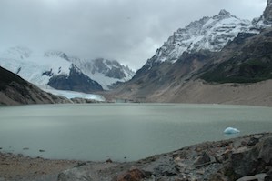
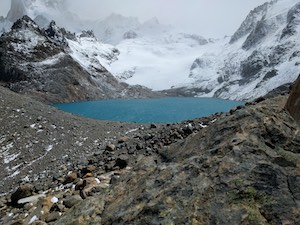
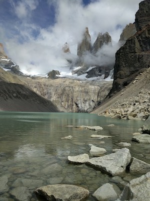
Today's hike is slightly shorter and easier than yesterday's climb to Los Tres, but is nonetheless a long and full day of walking through this lovely country. Today our aim is Cerro Torres, the single peak off to the left separate from Fitzroy, standing alone with a glacier at its feet. The hike is fortunately less dramatically vertical than yesterday's, and the weather is much better, no rain and actually rather warm. At our destination we have to climb a bit to get over the moraine, the natural wall around the glacier lakes freed after the glacier carved out the depression that then filled with water. This lake is stunningly blue, with a little iceberg floating in it and the edge of the glacier to one side.
One amazing thing about this unspoiled landscape is that all the streams and lakes are filled with potable water. It all comes straight from the glacier, and you can simply fill up your bottle from the stream and enjoy bracingly cold, clear water. Although there are a few campsites in the park, they are carefully patrolled and they have built latrines, so there is essentially no trash, no waste, and people are for the most part very respectful.
Today we end our hike in town again, and decide to try the cerveceria that serves their own pilsner brewed with glacier water (really pretty good). Naturally before beer Steve and I hit the helados again, this time for a bit of Andean chocolate with our WIFi. Love this place. While we were hiking, our laundry was done in one of the lavanderias in town for $10 a load, and we pick up some truly excellent T shirts as souvenirs. It's an adorable and very friendly place, this. The Hosteria is even more so, a tiny hotel of 8 rooms that feels like the very best B&Bs. There is a wood fire burning in a large central fireplace, surrounded by chairs with sheepskin covers and big comfy cushions. You can buy a bottle of wine and they'll write your name on it, then keep it behind the counter for you during your stay. After a warm shower, I pad downstairs in clean clothes and hiking socks, no shoes, and warm my aching legs by the fire, a glass of excellent Malbec in hand. Then they serve a delicious meal including a perfectly cooked steak and local chocolates. It turns out their view of the peaks is extraordinary, and they are right on one of the hiking trails. Given you can get WiFi in town for the sacrifice of eating excellent ice cream, it's pretty much perfection.
Don’t look down, it’s a long long way to fall
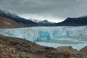
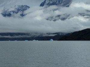
Today we are off to walk on a glacier! Not content with just looking at them or drinking beer made from their excellent water, it is now time to walk on one. Our target is the Viedma glacier that feeds the Lago Viedma, a large lake that we rounded to get here from Calafate. About an hour's drive from El Chaltén we reach a boat dock, from which we take a boat about another hour to the foot of the glacier. The last 15 minutes or so we see an increasing number of small icebergs in the water, recent calves floating along down the lake. They are not so dense as to impede navigation, but we do wind around them on our way.
This glacier moves at almost 3 meters a day, so the company that has the concession from the national park has to change their route for this glacier walk about every week, as the landscape of the ice changes. Over the last 10 years, the edge of the glacier has migrated a bit so that we actually have to hike almost 90 minutes to get to a good spot to climb on! The hike to the glacier is tough, steep and rocky, and the very last descent is actually by ladders bolted to the wall. (We went back the same way, and I'm split on whether up or down was worse.) Once we finally make it down the edge, we are fitted with crampons and taught how to walk on the ice. The key to this is stomping, honestly. You essentially have claws on your boots, and you need to jam them in the ice so you don't fall. There are more instructions, but it pretty much comes down to this.
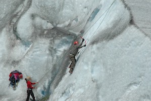
We start our ice walking experience by climbing a rounded hill, then traversing a slope, and then walking over a narrow bridge of ice between two icy pools of water. And then we keep doing that for an hour. I thought I had pretty much banished my fear of heights years ago, but it turns out that I do have a healthy fear of heights when ON ICE. I stomp away and try not to hyperventilate. It is surprisingly not frigid on the glacier, which is somehow unexpected, but whenever you stop you do notice a brisk wind and some rising cold from the ice. We finally reach a little flat area where we unpack our lunches and take a short rest. After lunch, they set up some belaying lines and offer the group the chance to try a little ice climbing. I was content to sit there perched on my rain pants, keeping my feet firmly clawed into the ice, but Steve decided it looked like fun. Next thing I know he's scampering up an ice wall, picks in hand, happy as a very cold clam. Craziness.
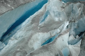
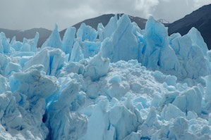
The glacier itself was rather in need of a good cleaning; not due to human action, but due to carving its way down from the ice field and picking up bits of Chile on the way. Some of this is ground to a superfine powder, but on the edges of the glacier where we are walking there are also small bits of rock. There are cracks and holes in the ice that reflect the water beneath, and as the sun shifts these elliptical holes are shadowed in brilliant blues, from a pale sky blue to deep royals, intense and saturated against the ice and the red rocks of the hillside behind. As you look across the glacier, it looks almost like a meringue, the dust on top highlighting the rolling hilly quality of the top layer of ice. As we walk we hear a loud noise like thunder; this is a piece calving off into the water. Hopefully not too near our waiting boat.
The hiking guides for the glacier walk are all young, athletic, skilled climbers, and aggressively nice. They gamely help us over the rough bits, while themselves perched on ledges with no concerns at all. They help people over the gaps and cheer us on, and they seemed to really enjoy watching all the amateurs try out climbing. On our way back from lunch, they even broke out some Tia Maria coffee liqueur and chipped out some ice so we could have a little drinks break. Once we made it back to the boat, we spent a few minutes drifting in the iceberg field near the edge of the glacier. I was concerned that the engine had a fault or that we were stuck on something, but no, they were snagging a chunk of ice for a Christmas Eve party that night. They hooked it and hauled it up on deck, with plans to toss it in the back of someone's truck to get it to town that night. Definite style points.
On the way through town we stop for our now traditional helados/WiFi break, and our group picks up a large tub of the stuff for dessert this evening to celebrate the holiday. Christmas Eve is the big celebration in Latin America, and we are looking forward to a festive dinner. Our lovely hosts provide not only another excellent dinner, but also a champagne toast and warm wishes for the holiday. Felicidades from El Pilar, warm and happy on Christmas Eve night.
Where are we going to?
With great reluctance after 4 lovely nights, we must leave behind the fabulous El Pilar and El Chaltén. Our goal today is the Estancia Helsingfors, situated far on the southwestern edge of Lago Viedma. This requires us to drive all the way to the eastern tip of the lake (where we had dinner on our way to El Chaltén), and then back west along the southern shore, about 4 hours total, the second half on a gravel road. At the eastern corner of the lake where we meet highway 40, there is an old estancia called La Leona. Aside from being the best tea/coffee stop for miles, this place is now famous for being one of the places Butch Cassidy and the Sundance Kid stopped on their way through Latin America. As we drive west toward the Estancia, the mountains come out from the clouds, and we see a progressively better view of the jagged and ice-covered peaks. We also drive by working ranches, with sheep and horses sharing the stubby grass with the local guanacos. One lake is dotted with pink flamingos. As we drive along, suddenly the driver stops the bus and leaps out. We were afraid we had hit something, but no, he was catching an armadillo that had been sunning itself by the road. That is agility! As we approach the mountains again the land is notably wetter and greener, still a flat plain with no trees (aside from those cultivated near the rare estancia). All the better to see guanacos.
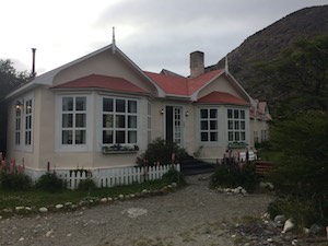
Estancia Helsingfors was founded all the way at the southwestern edge of the lake in the early 20th century by a Finnish gentleman, and his family has lived here since. It was once a ranch, but in the 1960s when the government formed the national park they claimed most of the land. The family was allowed to live in their home until the last member of the family died, and they were given some acres of land around the house. They have turned this into an elegant guesthouse, doing business offering tours of this part of the park by foot or horseback. It is a lovely and somewhat more elegant place than El Pilar, with extraordinary food and much more enthusiastic showers than the last hosteria. It is somehow not as simply welcoming, but lovely nonetheless.
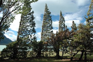
We are met with a traditional asado barbecue, a slow-roasted lamb accompanied by roasted vegetables and good local Malbec. It is delicious and it is delightful to sit at tables out on the lawn, watching the lake and hearing the wind in the trees. After lunch we set out for a short hike to "Windy Point", about 90 minutes away. Given the constant wind we have experienced to date, one does wonder exactly what you have to do to earn the name Windy Point. As we leave the estancia, we see that the windbreak of beautiful old trees has a unique feature - all the branches are on one side of the tree, the other side of the trunk is completely bare. They are all entirely lopsided, even though the trunks are straight. The hike is lovely, and when we reach the point we can in fact see where it got its name as we struggle to stand upright in the face of the constant strong wind off the mountains. From this point we are able to see the edge of the glacier that forms this lake, part of which we walked on yesterday. We return to the estancia for a lovely shower and dinner, protected by the one-sided trees from the howling winds outside.
But that’s not the point my friend
Our morning today was quiet, and we get an uncharacteristically late start (10a!) for our hike today to the Laguna Azul. Yes, the Blue Lagoon. Not that one. This is a relatively short (15km) but challenging hike, due to the constant climbing, a total of 2200 feet, the last 1000 in a short 1.5 km. We set off from the estancia climbing slowly uphill through a landscape of low shrubs and tough grasses. The path is narrow, not often trod, and dotted with the evidence of horse traffic. As we top each of the rolling hills, we feel a gust of the constant westerly wind, which while it can be somewhat cooling can also lead to uncomfortable moments of near-strangulation from tightly secured hats. I'm not giving mine up, no matter how tough to keep it on, as I wound up getting sunburned on the glacier the other day and need to avoid further sun exposure. (Who gets burned on a glacier? Doesn't that seem wrong?)
After 5 km of slow climbing, we get to the 1.5 km of steep climb, and it does certainly live up to the billing. Another couple from the estancia opted to take the horses the first 5 km and are only climbing this last bit. While I'll admit the first 5km were tiring, this is just tough, loose rock and mud, and the path is lined with tough shrubs with wicked thorns. Gaiters are a good idea, and save me some injury, but the bushes are tall enough that you can still get hit above the knee! You also want to be very careful what you grab to get your balance, as some of the foliage grabs back. It's all worth it, though, as we find the Laguna Azul. This is a small glacier-fed lake nestled in the hills, a bright intense blue, with a small glacier at one end and the start of a river at the other. We have been following the river uphill, seeing its waterfalls and at times crossing the brisk cold waters. We walk over to its source and can stand on a flat rock right at the mouth, enjoying the transition from blue lake to briskly running river. We find a comfortable set of rocks and sit down to lunch, filling our water bottles direct from the lake. We can see the glacier and its snowpack, and small waterfalls running along the sides as the glacier melts and its waters cascade down to the lake. While we watch, a small avalanche knocks some snow down the hill toward the lake. The strong wind gusts from time to time, causing spray and even a little surf on this tiny lake. We are collecting lake colors, from the milky turquoise color of Lago Viedma to the clearer mid-blue of Lago Argentina, and now this darker intense blue. As we watch, the sun comes around and you can just make out some blue shadows on the glacier high above us.
We navigate the steep downhill and slowly wend our way back to the shore of the lake in the distance. As we walk, the wind worsens noticeably, and the gusts are enough to push you off your feet. We are going slowly downhill, and at times if you are on a steeper portion it can be a bit treacherous. One of our group was blown to her knees and her glasses flew off, landing in a nearby thorn bush. I also was pushed over, landing on my knees directly in another thornbush. Gaiters can only do so much, and I wound up a little perforated. Harrumph. However, we finally made it back to the estancia, intact and with our much-battered hats (and my rather battered pride). As we shower and change the wind howls around the building, the one-sided trees no match for the gale. It sounds by turns angry and excited, and I for one am glad that I don't have to venture outside again to reach the nice warm bar and dining room. There are waves crashing on the shore of the lake, and you can see whitecaps outside. I'll stay here and have some excellent lamb samosas and chocolate cake with homemade limoncello, thanks... (Chocolate and limoncello are known cures for thornbush injuries. I looked it up. Well, I tried to look it up, but the internet was dodgy, so I made it up. Same thing.)
Rolling on in
This morning the wind has finally died down, just in time for us to leave the Estancia Helsingfors and head back along the lakeshore to Calafate. Just before the now-traditional tea/coffee/restroom stop at La Leona, we take a short break to walk up a hill to find a small petrified forest. These are gigantic logs now turned to stone by the minerals that deposited during the last ice ages. Apparently there are also a number of fossils in this area, which had been a river delta millions of years ago and was then covered by glaciers. After examining the petrified logs (they don't seem that scared to me...), we finally bid the gravel road farewell. Our driver is hugely excited to find paved road again, and I have to agree. I discovered that the "shake to control" feature of iPods is hugely annoying when you are on a gravel road. My damn iPod had a life of its own, pausing, skipping tracks, doing whatever it wanted like it was possessed. From La Leona we continue another 90 minutes south to Lago Argentina and to Calafate, which now looks GIGANTIC after the last week of being somewhere 30 minutes further down the road from nowhere.
Calafate is not a gigantic city, it's about 20,000 people. Similar to El Chaltén and Ushuaia, it has grown substantially in the last 20 years. The government has invested in infrastructure, including schools, hospitals, a nice airport, a boulevard along the lakeshore, street lighting, etc. Famously, the Kirchners have a summer house here, relatively modest and in a regular neighborhood, but no doubt part of the reason for the attention. As much as we have enjoyed the estancias, it is nice to be in a real hotel with working internet (!), a TV (!!), and nearby shopping. This is quite clearly a tourist town, but not a pure hikers' community like Chaltén; this is more like Aspen or Tahoe. Some people live here year-round, but there are a lot of second homes and a lot of seasonal tourists.
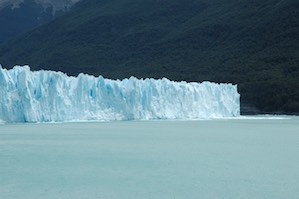
In the afternoon, we head to the closest part of the national park (we are now at its southern end, whereas Fitzroy is at its northern extreme). There we can see our second glacier, the Perito Moreno. This glacier sits only 50 km from town down a paved road, and the government has invested in a huge project to build viewing stations and boardwalks to make it accessible to all. We drive up to a hopping visitor center with a tea shop and souvenir store, and then walk out on a very solid and wide metal boardwalk that covers what must be miles of territory along 6 different circuits with viewing platforms scattered along the way. The circuits range from the most challenging, with lots of staircases, to one that has an elevator and ramps and is accessible. This place is really amazingly well built, and quite a contrast from the northern section of the park, which had beautifully maintained trails but was clearly for serious hikers and campers only.
The glacier feeds Lago Argentina, and is the only glacier in the area that is stable to slightly growing each year. It is about 25 miles long and 5 miles wide, and it ends at a peninsula of land. Here the glacier stops and calves off into the lake, with two faces, a north and a south, on either side of the peninsula. The glacier moves 1-2 m/day (slower than Viedma, but not by much) and calves constantly. As we walk along, we can hear the thunder of ice falls and calves, although most of the time you can't see them, as by the time you hear the noise the ice has already fallen. The evidence of calving floats down the lake toward us, and you can see new falls from time to time boiling up from the water.
Most of the time there is a channel of water that runs along the peninsula, connecting the main lake to the inlet on the other side of the glacier. From time to time this fills with ice and the connection is lost, until the ice collapses and it opens again. Right now it is closed, with a large hunk of glacier in the way that has formed an ice cave. As we watch, some ice tumbles down near the entrance to the cave. Who knows how long it will last! The glacier is about 50 feet high, and it is hard to take in its scale. As we climb up, we can see the entire length of the glacier, the mountains in the distance and the snowpack that forms it. For a moment it seems inevitable, rushing toward us inexorably. Then as we descend to eye level we see how enormous this is, and can see the gigantic crevasses and mounts that seem so smooth from above. This glacier is a bit cleaner than Viedma, but still has that meringue look to it from some angles. Once again when the light hits just right you can see incredible deep blues in the shadows of the ice. As we walk and marvel, we periodically hear the noise of ice falls, cracking and thundering so close by. I can see why you don't walk on this glacier, and why they moved the former hiking path onto this much sturdier (and further back) boardwalk. There are boats that come up toward the glacier on both of the faces, looking tiny next to the ice wall, but they stay far enough away to avoid crushing.
After a very happy couple of hours (and roughly 500 glacier pictures, proving glaciers are cool but only 50% as cool as penguins), we head back to town. It's such a pleasure to have pavement! We head into town to wander around a bit and find dinner in one of the many restaurants that cater to the tourist trade. The stores are full of handicrafts of dubious origin and high prices, and the restaurant prices are high (US levels), but the food is excellent and the Malbecs continue to be extraordinary, so no argument from me. We wind up at a cool local wine bar for dinner, then get helados at the store near our hotel to see us through the walk back. It's getting dark as we wander (so it's about 11pm), but it's not too cold and there is no wind, so it's a pleasant stroll.
As we wander around town, we can't help but notice that there is a definite theme to the names of businesses. Perhaps not surprisingly, they all are named Glacier. Glacier tours, glacier bar, glacier outfitters, etc. There are two different ice bars (one called PolarBar and the other Yeti). More troubling is glacier cab; who wants a slow-moving cab that is constantly falling into the lake? Also glacier pizza sounds unappetizing, and glacier hotel just sounds cold. At least our hotel is not named for a glacier, and is in fact rather overheated. We find one of the two English-language channels (CNN and a movie channel specializing in movies you don't remember from 10 years ago with vaguely recognizable people in them) and settle in to enjoy internet, power, and a complete lack of howling wind.
Rainbow Tour
It is time to leave Argentina and head into Chile and the Torres de Paine national park. Interestingly, Paine is derived from a local language word for "blue", referring to the blue lakes, and is not the name of a European who owned the land/thought he discovered it. I find this vaguely reassuring. It is also pronounced "Pine-ay", not "pane", which means I've been saying it wrong for...a long time. This park is just the other side of the mountains, very slightly south of our current location, but getting there will take all day. We settle in for a long drive and a little boredom. At least I downloaded the new Economist double issue last night. The drive to the border is relatively uninspiring; it is dry and dusty with few buildings or cars. After 4 hours we finally arrive at the border. This is a new crossing point and is staffed by the military, not by the immigration services. It's little more than a small building with a few windows; no amenities, nothing much to see. We wait for about 90 minutes to exit Argentina, then drive a few miles down a gravel road, then wait another hour or so to enter Chile. It's 4pm by the time we are finally in Chile and can have lunch! However, it's almost worth it, as lunch is excellent chacarero sandwiches with french fries. Finally a couple of hours later we arrive at our inn for the night, the Hosteria Lazo on the shore of Lago Verde on the edge of the national park. An entire day of driving essentially in a big U, as Calafate is just behind the mountains we can see from the window. *sigh*. The hosteria is very nice, if a bit basic, and they turn off their generator between midnight and 6am. Fortunately there's sufficient twilight and pre-dawn glow that we have light except between 11:30 and 4:30, so you don't really miss much!
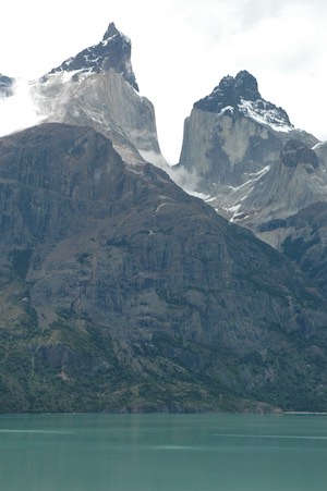
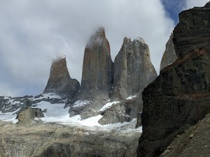
In the morning, we set out direct from the hotel for a hike to a lookout point with a view of the full Paine range. It can be difficult to see the whole thing, partially due to its size, and partially due to clouds obscuring the peaks. The range looks different from every angle, as different peaks come into view. Interestingly, the Andes are not far away; in fact, you can see them just a valley away, and the Pacific ocean is only the other side of that range, really quite close. Paine is a much newer range, created by volcanic action rather than tectonic movement, the same process that formed Fitzroy. Similar to Fitzroy, the peaks are sharp and jagged, formed by glaciers sliding by and eroding the softer rock, leaving granite behind. In Paine, some of the peaks have a thin layer of darker sedimentary rock at the top, a layer that was never covered with glacier. This gives some of the peaks the look of caramel ice cream with chocolate sauce on top. (Sorry, I'm writing this before dinner.)
Our hike is relatively easy, and brings us to this amazing lookout where we can see the entire range. The sun comes out and the clouds clear, and we can see the whole thing in front of us, as well as several of the glacier lakes of varying shades of blue. The lakes closest to the glaciers are a milky turquoise color, then they get darker and clearer the further away you get, as the sediment settles. The deep blue lake in front of us looks almost Caribbean, and you would be tempted to just dive in. One thing holding us back is the amazing Patagonian wind. This is ever-present, but has been particularly strong in the last few days. Today as we hike we are sometimes sheltered, but at the lookout there are gusts so strong you almost fall over, and between gusts the wind is so strong that anything not firmly tied down promptly flies away. Hats are an impossibility and you just stand there, buffeted, leaning into the wind, desperate to keep your feet. It's so ridiculous you just have to laugh, or at least you try to if you can get your breath! The downhill from the lookout down to the lake is...impressive. 400 meters, very steep, on loose rock. I maintain my dignity (barely) and manage it without actually sliding down on my rear, although I admit it was a close thing. Better a slightly abraded set of hiking pants than a bad fall. This time I didn't have to actually make that choice, so yay!
Our hotel tonight is the stunning Hotel Lago Grey. It is on the shore of the lake, facing the glacier that feeds the lake and the western aspect of the range. The hotel is constructed of a series of low buildings along the shore, each with glass walls facing the lake and the Paine range behind. It's very new and modern, all exposed beams and steel. The rooms are gorgeous and extremely comfortable, like a boutique hotel, with rainfall showerhead, heated stone bathroom floor, and satellite TV! It's quite a change from the last 10 days, and by far the most modern place we have been on this trip. It's like a different world from the very nice and comfortable but nonetheless rather basic hosteria we have been enjoying. I write this with a pot of excellent tea while using the WiFi in the hotel bar, looking out the window at the range and the glacier and some little floating icebergs on the lake. It's extremely nice.
Chile is not that different from Argentina, at least not in this sparsely populated Patagonia region (in some ways, it's probably more that Patagonia is very different from the rest of both countries). One notable difference is that the Pisco Sour is apparently a thing in Chile, and is (so far) the official welcome drink. This is amazing, as I LOVE Pisco Sours. I have started a Pisco Sour scale of our hotels and restaurants, and I'm happy that in a short hour I'll have the chance to add the Lago Grey to my contestant list. My injuries at this point are largely the horrific peeling sunburn on my face that I acquired when on the glacier a few days ago, a slightly sore left ankle, and a thorn-bush related cut on my finger. I checked, and Pisco Sours are the official remedy for both sunburn and thornbush injuries.
You’re losing strength, not style
Good morning from the gorgeous Hotel Lago Grey! Our hotel room windows show us a grey, rainy, cloudy morning. We have been lucky to have amazingly good weather so far this trip, but I suppose into every hike a little rain must fall. (I know, I'm mixing musicals, but bear with me.). BBC brings us nothing but depressing news, so we are happy to go out hiking despite the weather. Fortunately during breakfast it starts to clear, so that our morning excursion is really more slightly damp than seriously wet. We take a short 1-hour hike out on a spit in the middle of Lago Grey to a lookout point on a small island, from which we have a wonderful view up the lake to the glacier. Small icebergs float by, content to drift in the rain to their inevitable watery doom. The rain just spits a bit, nothing bad, and there is for some odd reason no wind, so it's actually quite comfortable. The lookout is nice, and fortunately the glacier is visible despite clouds.
We return to the hotel to pick up all the rest of our stuff and head out to a different hiking trail for the afternoon, this one in the middle of the range. We started along the Grey river and hiked toward a lovely waterfall, then further up to a lookout from which we can see straight up the French valley. The weather is gorgeous, warm and clear, and completely without wind. This is astonishing on several levels -- apparently it rains 340 days of the year here, and the wind is continuous. So the blue skies, warm day, and lack of wind is just confusing. We de-layer and slather on sunscreen (well, I already had some on, as it's me). The view of the French valley and associated glacier is lovely, and we are able to enjoy it without wind trying to blow us off the point.
Along the walk, we see the remnants of a devastating fire from 2011 that covered large parts of the central and western parts of the park. This was started by illegal campers, avoiding paying a camping fee by setting up just off the normal sites. The ever-present wind blew the sparks across rivers and lakes to spread almost without control for a month. Windbreaks are somewhat meaningless in this setting. Finally it stopped spontaneously, but the dead burned trees are still in place, white ghosts on the green hills. It is strangely beautiful.
This evening we move hotels again to the Hotel Las Torres, on the eastern side of the range, from which we will do a long hike tomorrow. Today was pretty but not particularly long (5 hours total) and also not particularly challenging. Tomorrow is our last day of hiking, and we are going out with a bang on one of the longest, toughest days of the trip. But we'll make it. At least this hotel has decent WiFi and a very nice bar. So if we survive we can catch up on email tomorrow evening, post-shower, triumphant, enjoying a Coke Zero and a Pisco Sour. I'm confident!
We weren’t quite sure, we had a few doubts
When last we saw our heroes, we had checked into the Hotel Las Torres and were looking forward to our last, big hike. New Year's Eve dawned clear and surprisingly wind-free, and we set off early for this final, hardest, hike of the trip. The hotel is private, but is surrounded by national park, which as you can tell is a bit of a theme. Like other local landowners, the family that has ranched here since 1910 made a deal with the national park to keep much of their land (with certain restrictions) and now run a thriving hotel, several campsites, a horse ranch, guide services, and I think a couple of bus lines. The hotel is one of the largest we've stayed in, and it's a sprawling complex of rooms, a restaurant, and a lovely bar with a cathedral ceiling and windows looking out on the party piece, the Torres of the Paine range. Our goal today is to hike up to a glacier lake near the foot of the Torres, some 3000 feet above us. OK. We can totally do this.
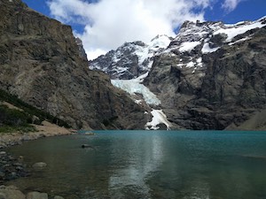
The first hour of the climb is rather exposed and hot, particularly without the perpetual wind. The next hour or so we climb through the forest, sheltered and cool, until we reach a hiking refuge (run by the hotel, of course). After a pause for fresh glacier water and surprisingly nice toilets, we continue to head up the trail through the forest. After about another hour, we get to the steep part of the climb (because the bit so far was just a warmup). We gain about 1000 feet over less than a kilometer, and it's what the Australians would call "a bit of a scramble" over big rocks, emerging above the tree line. From there we traverse a rocky slope and wind up emerging at a beautiful small lake fed by the glacier above us by a multitude of waterfalls. The towers are right in front of us, and as we settle in on the softer rocks to eat lunch, the clouds clear and all three emerge, glorious and highlighted in the sun. It's pretty clear that this rocky shore would be very unpleasant in the usual wind, but without wind it's actually lovely, just cool enough to be pleasant, and you can perch on a flattish rock and enjoy the view without discomfort. We scramble over the rocks to get to the water, but there's no beach, just enough of a flat spot to perch, enjoying the cold water and the lovely view.
The hike down to the hotel is long and at times hot when we are out of the forest, but we manage. It's interesting that downhills are now just as tough as uphills, and my knees certainly notice the big drops more than they used to! We are passed by some young hikers practically doing parkour down the slope, and by a couple of young children scampering down wielding hiking poles with more panache than utility. At the end, it was 4000 feet of climbing (and then again 4000 feet descending), and 9 hours. My feet were sore before we even got all the way down.
This being New Year's Eve, the hotel is getting geared up for the holiday, with decorations and a big projection screen in the bar. There's a special dinner, which is amazing (although no chocolate volcano as the day before), and a champagne toast. Some of our group stayed up in the bar to see in the new year, but we dragged our tired selves to bed by 11, and didn't even wake up when the crowd cheered. Apparently they set up iron letters spelling out "Las Torres 2017" that were lit by horse riders in very dramatic fashion in lieu of a ball drop. Sounds cool! Too bad we didn't catch thzzzzzzzzz
Have I said too much? There’s nothing more I can think of to say to you.
2017 dawned clear and cool, welcoming us to the new year and to much-needed coffee. As we say farewell to Paine, it actually seems like a very apt way to close the annus horribilis that was 2016 for many of us. Leave it on the mountain to fly away and enter the new year fresh (if a bit sore of leg). Today is a long drive south to Punta Arenas, the closest airport. It's too much of a bother to cross the border again and head back to Calafate, apparently. We leave the national park, bidding farewell to mountains, glaciers, guanacos, and all the beautiful scenery. As we drive south, the scenery remains greener and somewhat more lush than the arid climate of Argentinian patagonia, as we are closer to the mountains and at times are only 20 miles from the Pacific. It's easy to forget just how narrow the continent gets down here!
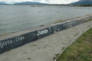
We stop in a town called Porto Natales, a former fishing town now turned traveler waystation, as it's just about the only place to get lunch on a national holiday. We walk around a bit to stretch our legs, enjoying the shore (it's a port on one of the many channels in from the Pacific). The town seems curiously obsessed with their latitude, as it is written proudly on most buildings and even painted on the sidewalk of the promenade by the water. Even more curious is the painted "Jump!" written on the same promenade, facing out, as though encouraging people to just pack it all in and drown themselves. As if in keeping with this theme, there are two (actually quite cool) statues of people swinging out over the water just ahead. They are at the edge of the waterfront skate park and playground. It's a cute little town, conveniently located at 51.73 degrees South if you ever need it.
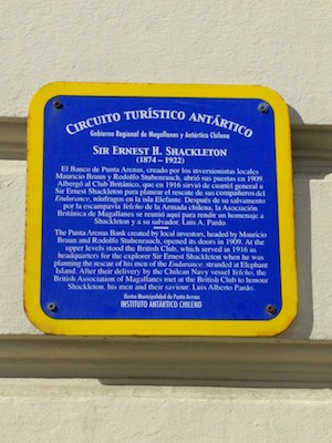
After lunch, we climb back in the bus for another few hours south to Punta Arenas, arriving around 5. This town on the Straits of Magellan was once a huge shipping waystation, one of the largest commercial ports in the world, and the jumping off point both for Antarctic exploration and Patagonian settlement. It was rich, run by a few families who dominated business and the southern reaches of the continent for decades. Since the Panama canal, its' dominance in shipping has of course waned (although not entirely disappeared, witness the port and many shipping containers). The downtown area reflects this faded glory, some gorgeous late 19th century buildings around a town square hailing the great Magellan only a few blocks from the famous Straits. As we wander around town, we see a number of blue historical plaques marking the locations of buildings in which famous explorers had their last hot meal before setting off to find the pole and freezing to death. (Or, alternatively, from which they sent mail home saying that they had NOT frozen to death and had experienced varying degrees of pole-finding success.). Perhaps appropriately, our hotel is filled by a tour group setting off tomorrow to also find Antarctica, with similar hopes not to freeze to death. There is a promenade along the Straits featuring a newly dedicated monument to various explorers, both frozen to death and not, strangely with their backs to the Straits. We return along a formerly beautiful avenue with a park dotted with very sturdy-looking monuments to various commercial heroes of the late 19th century and early 20th century, presumably none of whom froze to death, although judging from the angry political graffiti around town that might be considered unfortunate by at least some of the current residents. Unfortunately all the stores are closed for the holiday, although given the location it's pretty much all hiking gear (more highly appropriate Patagonia stores) and some dubious-looking "handicrafts". Clearly this was not a trip on which to do our holiday shopping for the year. At least our hotel has satellite TV with at least 2 channels in English, plus the amazing "penguin channel", which as far as we can tell is the local version of the Yule Log station, showing mostly local ads with footage of penguins in the gaps. Penguin TV rocks.
It takes a long time to get home, first flying to Santiago, then a long wait in that airport until the AA desk opens so we can recheck our bags, then a quick rest in the airport before boarding an overnight flight to Miami and onward to Boston. We were on a different flight out of Punta Arenas from the rest of our group, leaving several hours earlier, but they caught us up at the (closed) AA counter and we wound up hanging out in the club together before getting on our various flights home. It was a small group, only 8 people, and we had a really good time getting to know them all. Just lovely people, and it's good to like them if you're going to spend two weeks toiling up mountains and staying in tiny inns with no distractions!
In any event, I write this last bit from the club in Miami, and it's time to send it so we can board our flight home. Tired, a bit sunburned and windburned around the edges, still with some residual soreness in the calves, but happy. Patagonia is gorgeous, and totally worth hiking despite the egregious lack of temples to climb.